115 years of hard work
In August 1896 the owner of Westonbirt, George Holford, wrote to Mr Thistleton Dyer the director of Kew Gardens. “I will certainly take your advice about having a catalogue made of the trees and shrubs. In fact I have left instructions with Chapman and Rattray to begin it while I am away from England."


The final result of this was a catalogue published in 1927.
When the Forestry Commission took over in 1956 they embarked on re-cataloguing the collection. From an article in 1964: "Unfortunately, neither Jackson’s original catalogue nor Mitchell’s subsequent planting records wer specific enough about the planting site for us to run down the specimen in all cases". Also, a large number of labels had been lost, especially the lead ones which were often gnawed to illegibility by squirrels.
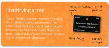
The present day labels give a wealth of information about the plant. They are however still enjoyed by the squirrels.

Eventually a printed catalogue of many pages and a set of maps provided the information about the plants in the collection. To deal with any updates new plantings or plant deaths a new list would be printed and dots drawn on the maps or rubbed out. Searching for a particular number on a map was time consuming.
The next step was to create a more modern database and a computerised map. On this in-house map we can display all the live trees but we also retain information about the location and type of a deceased specimen (great if there is an error as the tree can be brought back to life!) Now you can type in the number and the map will zoom to the correct location. This combined system is the engine behind all the work we do on the collection and our decisions about what to collect, propagate and plant in the future. Regular checks are made (much of it done by skilled volunteers) to keep the information up-to-date.
Why keep this information to ourselves?
What have we got and where is it?
These were the main questions we posed when asking a company to develop a web based interactive map for us. Since the site was launched in April it has been used by more than 2,000 different people worldwide.
